Christopher Alexander saw that, "unable to cope with the complicated information [the urban designer] is supposed to organize, he hides his incompetence in a frenzy of artistic individuality...In this atmosphere the designer's greatest gift, his intuitive ability to organize physical form, is being reduced to nothing by the size of the tasks in front of him, and mocked by the efforts of the `artists.' What is worse, in an era that badly needs designers with a synthetic grasp of the organization of the physical world, the real work has to be done by less gifted engineers, because the designers hide their gift in irresponsible pretension to genius."[2] The problem as stated here seems as relevant and novel as it must have seemed then. This passage comes from Notes on the Synthesis of Form, in which Alexander begins to formulate a theory on how designers might begin to use formal logic to solve design problems. Very generally, the theory involves finding the entire set of design problems that must be solved or conditions to be met and determining which are related to each other and in what order to solve them.
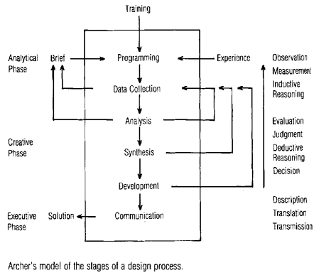
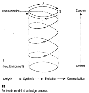
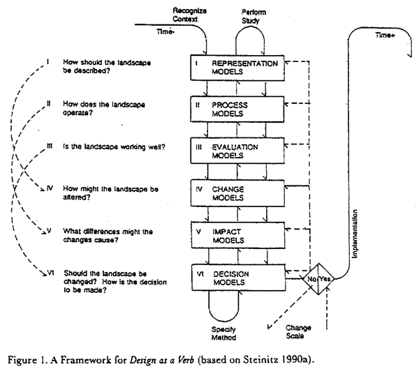
Alexander was not the only one to espouse this approach. In Design Thinking (Rowe, 1987), Peter Rowe states that in European design schools of the 1950s and 1960s, "attempts were made to describe the creative problem-solving process at work in design by way of the logical structure of overt activities that appears to take place. In other words, design was regarded as a series of stages characterized by dominant forms of activity, such as analysis, synthesis, evaluation, and so on" (p. 46). Furthermore, these theories usually incorporated an iterative property, to make explicit the process of designing based upon the information at hand and then refining the design by reevaluating the original set of information with respect to previous design solutions. Asimow (1962), Archer (1963-1964) and later Steinitz (1995) proposed variations on this "operational" model of the design process (Figure 2). Schön (1983) focuses less on the operational aspect of the model and more on its iterative properties, as the designer continuously reflects on the work.
These approaches to design were an attempt to solve "ill-defined" design problems. Rowe describes three types of problems, well-defined, ill-defined, and wicked. Well-defined problems, like 2x + 5x2 = 29, have obvious starting and ending points and rules to follow from beginning to end. Ill-defined problems, which Rowe believes encompasses most architecture and urban design problems, usually have desired goals, but the solution which will achieve the goals is unclear as well as the initial conditions. Wicked problems are those for which the goals, starting point and ending point are up for constant debate, like hazardous waste disposal. There is no specific result that can be agreed upon as the best possible solution to the problem.
Figure 2: Operational Models of the Design Process
Archer: Stages of a design process[3]
Asimow: Iconic model of a design process [4]
Steinitz: A Framework for Design as a Verb
Many of the ideas in Design Thinking are worthy of consideration, but Rowe's discussion of operational models and modeling is the most relevant to this work. He starts with Echenique's definition of models, "A model is simply a representation of relevant characteristics of a reality...a means of expressing certain characteristics of an object, or system, that exists, existed, or might exist" (Echenique 1963, p. 1). He then groups models into four categories: descriptive, predictive, explorative and planning. Descriptive models seek to explain what and why something is the way it is and how it works. Rowe would describe Lynch's city imageability concept as a descriptive model. Predictive models are either extrapolative, in that they predict the future based on what can be expected from looking at the past, or conditional, in that changes in inputs result in different outputs. Explorative models are, "designed to allow the discovery, by systematic speculation, of realities other than the one at hand that may be logically possible. Such speculation usually proceeds by exploiting the systematic variation of basic parameters used in a descriptive model" (p. 167).
Figure 3: A Hierarchy of Model Types (Rowe 1987)
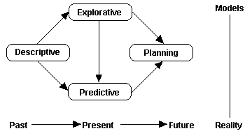
The planning model as Rowe defines it builds upon the other three types. In his planning model, descriptive models are required to understand the current state of affairs. Next, different interventions can be evaluated with a predictive model to generate possible solutions. The solutions are then ranked objectively according to their ability to meet stated goals. Explorative models may be used to generate predictive models, ranking schemes, or other decision support tools.
I have avoided allowing the applications developed here to fall into the realm of predictive or planning models because they are intended to be more pure. Those two kinds of models inherently require value judgments that must be made separately as each planning problem is faced. These applications intentionally try only to be descriptive (in the case of the node-finding algorithm) or explorative (the pattern-finding application). Too often the tendency is to create an application that makes decisions, as in Rowe's planning model. This is difficult, and not necessarily wise, as examples from the environmental field show us.
Carl Steinitz's basic theory of design is very similar to Rowe, Archer and Asimow (Figure 2). Although much of the work referenced here is from the 1990s, it refers to ideas that Steinitz has worked with for decades. In fact he says, "In 1990, after almost 25 years of applying GIS to many projects, I came to the realization that there was a common structure to this work, and I wrote a short paper entitled, `A Framework for Theory [applicable to the education of landscape architects]'."[6] This common structure takes the form of "A Framework for Design as a Verb" (Figure 2), where Steinitz illustrates a six-stage method where representation models explain how the landscape should be described, process models explain how it operates, evaluation models explain whether it is working well or not, change models explain how it might be altered, impact models explain what differences these alterations might cause, and decision models help us decide whether and how to act. His feedback loops (shown with arrows) relate these models to one another and shows an iterative pattern where each model can inform others.
Environmental Impact Assessments show how modeling can be abused. It was stated above that a model must start with a decision to choose certain relevant characteristics of a real object or system because it is too difficult to try to model all characteristics. The planning model then ends with a ranking of possible outcomes. These assessments are being conducted throughout the world using the exact same modeling procedure, as if the environmental concerns in, for example, an urban-industrial area like Los Angeles should be ranked the same as those in a mostly rural area like Vermont (where a large part of the economy is eco-tourism). The validity of these techniques has become an issue of general public debate recently as the U.S. Congress has called into question the U.S. Environmental Protection Agency's decision-making techniques. So although the environmental field is very advanced in terms of using GIS as a modeling and decision-making tool, they have perhaps gone too far in relying on analysis to make difficult choices which are as much a product of socio-cultural issues as technical ones. This is not to say that we should not strive to construct good decision making models. I simply want to emphasize that the move from a descriptive model to a planning model is a significant one, and is outside the scope of this work.
The most important descriptive model in the environmental field is presented in Landscape Ecology (Forman and Godron 1986), where the landscape is described generally in terms of structure function and change. Structure refers to the distinct elements that make up the landscape. Function refers to how structures interact. Change is the alteration of structure and function over time. It should be noted that all of these elements change with scale, so that a farm might be a structure at one scale, but at a larger scale, the farm structure becomes the separate structures farmhouse, dirt road, cropland, grazing land, hedgerow, etc. Structure can be more generally described as consisting of patches, which are relatively homogeneous areas, corridors, which are places along which living things travel,[7] and a background matrix, which describes the general landscape characteristics of the place. Edges are created where different landscape structures meet. For people, a residential neighborhood is a patch, while a highway is a corridor. At a larger scale, an apartment building could be a patch, which would then make every sidewalk and road a corridor and every stoop part of an edge. At a smaller scale for migratory birds, the chain of wetlands along the Atlantic coast is a corridor.
The patch-edge-corridor theory is similar to Lynch's district-edge-path, and may not be a coincidence, as Forman mentions Lynch as having "particularly elucidated structure and change in the urban landscape" (p. 29).
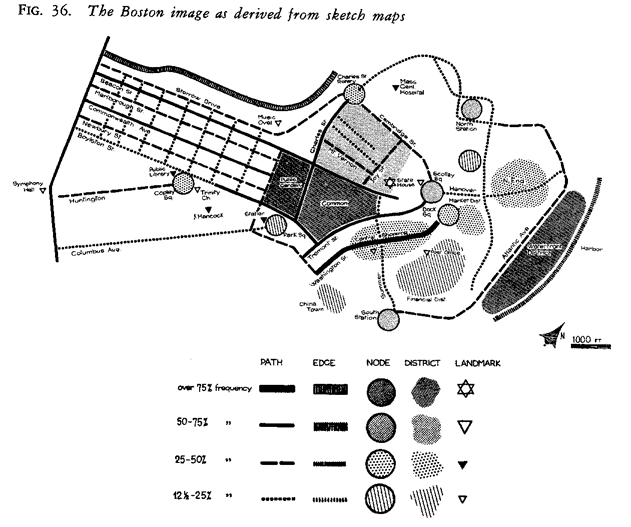
The Image of the City (Lynch, 1960) examines "the apparent clarity or `legibility' of the cityscape," and argues that, "a distinctive and legible environment not only offers security but also heightens the potential depth and intensity of human experience." From this starting point he proceeds to develop a theory that in order for a city to be legible, certain elements must be readily identifiable by its inhabitants; these elements are nodes, paths, districts, edges and landmarks. Nodes are transportation junctions or concentrations of activity. Paths are channels along which people (in vehicles or not) customarily travel. Districts are sections of the city that have some common character. Edges are boundaries between areas. Landmarks are points of common reference, like the Empire State Building in New York City, the Citgo sign in Boston, or the Space Needle in Seattle.
Working from this theory, Lynch tells us how a poor city image can be found (through sketch planning and input from residents) and how it can be corrected. The resulting `highly legible' cityscape will then be a much more interesting and satisfying place for people to live and work. In order to define a city's imageability and later correct it, the designer must be able to find the nodes, paths, districts, edges and landmarks as they are perceived by the city's inhabitants. This work show how a geographic information system could begin to support this process by finding nodes. The use of GIS is important here because Lynch's method involves field investigation to find nodes, which limits the area he is able to study to the amount of highly trained human labor he is able to muster behind the effort. My method focuses on strategic use of digital data in order to create an algorithm which find nodes and is field-checked in a small area, but can then be used to find nodes over any area.
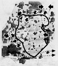
Figure 4: The Boston image as derived from sketch maps (Lynch
1960)
A Pattern Language (Alexander 1977), gives a much better analytic framework for urban design than Alexander's previous Notes on the Synthesis of Form, and it has influenced an entire field of inquiry concerned with `shape grammars.' These shape grammars have been explored mainly within the discipline of architecture, but the pattern language also deals with the urban scale. There are 253 `patterns' which descend in scale from the pattern `Independent Regions,' which describes how human civilization on the planet should be organized, to the pattern `Things from your Life,' which talks about what you should hang on the walls of your home.
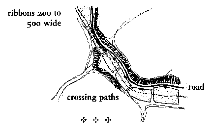
Alexander believes that a designer may use the framework by deciding which pattern best fits their task, and then use that pattern and a few patterns above and below that main one. As an example, if we were involved in economic development for `blue-collar' workers, we might start with pattern 42, `Industrial Ribbon.' This pattern would tell us that although industry is smelly, noisy, dirty, etc., it must be placed in or near neighborhoods so that people may understand the connection between the things they use in their daily life and the process of making them. Also as a practical consideration, proximity is important so that people do not have to drive to work and spend a great deal of time in travel to and from work. In situations where the industry requires too much land for their placement in the general urban fabric to be practical, they should be placed in an industrial ribbon, which would be near ring roads (pattern 17) and have truck and train access.
Figure 5: Pattern 42, Industrial Ribbon [8]
In planning this industrial ribbon, it would be important to take into careful consideration the idea of work communities (pattern 41), old people everywhere (pattern 40) and housing on hills (pattern 39). Descending in scale, we must consider the university as a marketplace (pattern 43), local town halls (pattern 44) and necklaces of community projects (pattern 45). More patterns may be considered, with each likely to be less important to the project as they get farther removed in scale. So this is a comprehensive guide to urban design, though it's organizing principles are distinct from Lynch's.
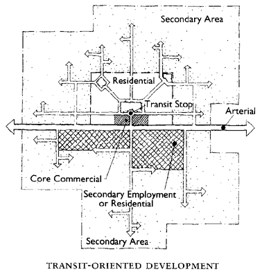
The Next American Metropolis (Calthorpe 1993) is an example of the latest trend in urban design, "the new urbanism," which advocates high-density walkable towns with a greater mix of land uses than current zoning policies generally allow, narrow urban streets which allow the street to be used as public space as well as transportation and buildings that relate to that public space instead of to parking lots. Calthorpe has expanded the theory to include a regional design scheme termed "transit-oriented development," (Figure 6) in which these new urban areas (which are designed to be small towns) are connected to each other and to a larger metropolis by public transportation.
These high-density, dispersed small towns are supposed to satisfy the American desire to live in a small town while still having easy access to the city. This type of development pattern is also intended to be ecologically sustainable by concentrating human populations in the least environmentally sensitive areas and encouraging people to use public transportation. As urban planners expand the scope of their work to regional planning, the need for information management and analysis strategies becomes even greater.
Figure 6: Transit-Oriented Development (Calthorpe 1993)
One area of research involves making analytic tools accessible to non-technical planners and the general public. This requires new kinds of interfaces to the information system as well as new kinds of information visualization techniques. Linsey and Raper have experimented with the provision of spatial analysis functions through a graphical user interface (Linsey and Raper 1993). The focus here is on allowing a user to create their own analysis by attaching a graphical front-end to Arc/Info's map display, database query, buffering and spatial intersection functions. Shiffer focuses more on visualization techniques than spatial analysis. His work seeks to create tools that allow the outcomes of complex processes to be better understood by the general public (Shiffer 1995). One example is that instead of debating the possible deleterious effects of airplane noise by explaining the decibel levels of planes, he presents a system that can play back the actual sound an airplane would make and allows it to be varied depending upon the type of plane and the observer's distance from the plane.
Dave and Schmitt (1994) have prototyped an information system that is tailored to the needs of designers, but their definition of urban design in the context of this project is very architectural. They decide that the traditional GIS model is inappropriate for urban design needs and instead use computer aided design (CAD) programs as their base system. This decision reflects their focus on three-dimensional rendering and visualization as opposed to spatial analysis. Although it is true that traditional GISs have weak three-dimensional visualization tools, by using the computer only as a tool to produce pictures of the urban environment, all analysis must still occur in the mind of the designer. This paper will argue that Dave and Schmitt's system, while having focussed applications, ignores the main benefit of using computerized information systems, which will be to create new analytic techniques that a person is able to conceptualize but not execute in their mind.
The National Physical Planning Agency of the Netherlands has been taking an approach to integrating GIS and design similar to the one put forth here (Schuur 1994), with a critical difference. They are working on using GIS for understanding the existing state of the physical world and having designers use thematic maps as base maps to draw on and design potential states of the physical world. GIS is then employed once again to rank and evaluate the potential designs. The critical stage where GIS and design is integrated still involves the intuition and skill of the designer to synthesize GIS information in their head instead of with the help of the computer, which is the same problem Alexander discussed in 1964 in his previously mentioned Notes. Since the designer's contact with the GIS database is still through printed maps, he or she can only see a certain amount of information at one time--with the pattern-finding application presented in this work, I endeavor to enable the designer to take into account more data than can be plotted coherently on paper.
Figure 7: Designing on a GIS base layer (Schuur 1994)
NOTE: some design
elements are exaggerated from the original